Difference between revisions of "Selbourne"
From wiki new
| (5 intermediate revisions by the same user not shown) | |||
| Line 2: | Line 2: | ||
| + | <big>Opened: '''01-NOV-1883''' · Closed: '''30-JUN-1937'''</big> | ||
| − | |||
| − | + | '''Location: situated approx. 43km W of [[Launceston]] at 41° 27' 0" South, 146° 53' 0" East''' | |
| − | * The closest post offices to '''Selbourne''' were at '''[[Black Sugar Loaf]]''' ('''[[Birralee]]''') and '''[[Rosevale]]''' | + | * The closest post offices to '''Selbourne''' during it's period of operation were at '''[[Black Sugar Loaf]]''' ('''[[Birralee]]''') and '''[[Rosevale]]''' |
| Line 14: | Line 14: | ||
''see [http://maps.google.com.au/maps?f=q&source=s_q&hl=en&geocode=&q=Selbourne,+Tasmania&aq=0&sll=-25.335448,135.745076&sspn=45.660664,100.546875&ie=UTF8&hq=&hnear=Selbourne+Tasmania&ll=-41.454049,146.874161&spn=0.30209,0.785522&z=11 Google Map] for an enlargement'' | ''see [http://maps.google.com.au/maps?f=q&source=s_q&hl=en&geocode=&q=Selbourne,+Tasmania&aq=0&sll=-25.335448,135.745076&sspn=45.660664,100.546875&ie=UTF8&hq=&hnear=Selbourne+Tasmania&ll=-41.454049,146.874161&spn=0.30209,0.785522&z=11 Google Map] for an enlargement'' | ||
| − | |||
| − | |||
<gallery widths=200px heights=200px>file: </gallery> | <gallery widths=200px heights=200px>file: </gallery> | ||
| Line 22: | Line 20: | ||
== Barred Numeral Postmark == | == Barred Numeral Postmark == | ||
| − | ''' | + | '''Second Allocation''' |
| − | <gallery widths=200px heights=200px>File:bn227 selbourne.jpg </gallery> | + | <gallery widths=200px heights=200px>File:bn227 selbourne 2.jpg </gallery> |
| − | + | * allocated barred numeral canceller ''''227'''' | |
| − | + | * examples of this postmark are rated '''RRRR''' | |
== Datestamps == | == Datestamps == | ||
| − | ''' | + | <big>'''Type 1'''</big> |
<gallery widths=200px heights=200px>File:selbourne type 1 (2).jpg | <gallery widths=200px heights=200px>File:selbourne type 1 (2).jpg | ||
| Line 48: | Line 46: | ||
| − | ''' | + | <big>'''Type 4a'''</big> |
<gallery widths=200px heights=200px>file:</gallery> | <gallery widths=200px heights=200px>file:</gallery> | ||
Latest revision as of 23:44, 9 June 2014
__this page is currently being prepared by R.E.__
Opened: 01-NOV-1883 · Closed: 30-JUN-1937
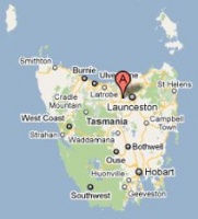
Location: situated approx. 43km W of Launceston at 41° 27' 0" South, 146° 53' 0" East
- The closest post offices to Selbourne during it's period of operation were at Black Sugar Loaf (Birralee) and Rosevale
see Google Map for an enlargement
Barred Numeral Postmark[edit]
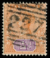
Second Allocation
- allocated barred numeral canceller '227'
- examples of this postmark are rated RRRR
Datestamps[edit]
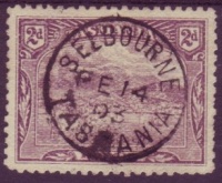
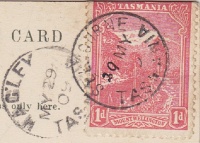
Type 1
- Earliest recorded date: 28-FEB-1896 · Latest recorded date: 07-MAR-1936
- Rated RR on Tasmanian stamps and Commonwealth issues
- Occasionally seen with 'day before month' dateline variation as well as alterations or additions to the dateline
Report an earlier or later use of the Type 1 datestamp here
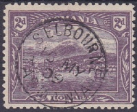
Type 4a
- Earliest recorded date: 17-MAR-1936 · Latest recorded date: 20-MAY-1937
- Rated RRRRR - only three examples have been recorded
Report an earlier or later or another use of the Type 4a datestamp here
| To the Index of Tasmanian Post Offices and Postal Markings
To the Tasmanian Datestamp Types main page |
Other Information[edit]
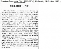
- notice in The Examiner regarding the departure of the postmistress in 1936
Links & References[edit]
| To the Index of Tasmanian Post Offices and Postal Markings
To the Tasmanian Datestamp Types main page |
Please contact the author of this page to report any errors and/or omissions or to provide better or 'missing' images, etc.
