Difference between revisions of "Williamsford"
| (7 intermediate revisions by one other user not shown) | |||
| Line 3: | Line 3: | ||
| − | Opened (as Deep Lead): | + | '''Opened (as Deep Lead): 21-Mar-1898 · Re-named Williamsford: 1-April-1899 · Closed: 18-June-1976''' |
| − | '''Location: situated 7km south of '''[[Rosebery]]''' on Tasmania's West Coast, | + | '''Location: situated 7km south of '''[[Rosebery]]''' on Tasmania's West Coast, Williamsford was located at -41.49'34" South, 145.30'29" East''' |
* Williamsford was called '''[[Deep Lead]]''' until 1-Apr-1899. | * Williamsford was called '''[[Deep Lead]]''' until 1-Apr-1899. | ||
| Line 16: | Line 16: | ||
| + | ==Barred Numeral== | ||
| − | |||
| + | <gallery widths=200px heights=200px>file: </gallery> | ||
| + | |||
| + | * BN213 was reallocated to '''[[Deep Lead]]''' from 21-Mar-1898 | ||
| + | |||
| + | * BN213 was previously used at '''[[Golconda]]''' (1880-1883), '''[[Wyniford River]]''' (1883-1894) and '''[[Dundas Junction]]''' (1891-1894). | ||
| − | |||
| − | |||
== Datestamps == | == Datestamps == | ||
| − | |||
| − | |||
| − | '''Type 1a''' | + | '''[[Type 1a]]''' |
| − | <gallery widths=200px heights=200px>file: </gallery> | + | <gallery widths=200px heights=200px>file:williamsford type 1a.jpg |
| + | williamsford type 1a (2).jpg </gallery> | ||
Earliest recorded date: '''9-May-1899''' · Latest recorded date: '''7-Jan-1937''' | Earliest recorded date: '''9-May-1899''' · Latest recorded date: '''7-Jan-1937''' | ||
| Line 38: | Line 40: | ||
| − | Report an earlier or later use of the Type datestamp here | + | [http://tps.org.au/bb/viewtopic.php?f=5&t=639 ''Report an earlier or later use of the Type 1a datestamp here''] |
| Line 48: | Line 50: | ||
Earliest recorded date: '''13-Apr-1937''' · Latest recorded date: '''9-Sep-1969''' | Earliest recorded date: '''13-Apr-1937''' · Latest recorded date: '''9-Sep-1969''' | ||
| − | Report an earlier or later use of the Type datestamp here | + | [http://tps.org.au/bb/viewtopic.php?f=5&t=639 ''Report an earlier or later use of the Type 5 datestamp here''] |
'''Type 5(s)''' | '''Type 5(s)''' | ||
| − | <gallery widths=200px heights=200px>file: </gallery> | + | <gallery widths=200px heights=200px>file:Williamsford.jpg </gallery> |
Earliest recorded date: '''18-Oct-1969''' · Latest recorded date: '''18-Jun-1976''' | Earliest recorded date: '''18-Oct-1969''' · Latest recorded date: '''18-Jun-1976''' | ||
| − | Report an earlier or later use of the Type datestamp here | + | [http://tps.org.au/bb/viewtopic.php?f=5&t=639 ''Report an earlier or later use of the Type 5(s) datestamp here''] |
| Line 73: | Line 75: | ||
<gallery widths=200px heights=200px>file: deep lead notification.jpg </gallery> | <gallery widths=200px heights=200px>file: deep lead notification.jpg </gallery> | ||
| − | 25-Oct-1898 - The Deep Lead Post Office has been removed to the railway station and Mr D J Sullivan appointed master thereat. | + | * 25-Oct-1898 - The Deep Lead Post Office has been removed to the railway station and Mr D J Sullivan appointed master thereat. |
| − | 31-Oct-1915 - The post office was destroyed in a fire. | + | * 31-Oct-1915 - The post office was destroyed in a fire. |
== Links & References == | == Links & References == | ||
Latest revision as of 23:46, 3 August 2014
Opened (as Deep Lead): 21-Mar-1898 · Re-named Williamsford: 1-April-1899 · Closed: 18-June-1976
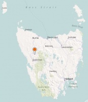
Location: situated 7km south of Rosebery on Tasmania's West Coast, Williamsford was located at -41.49'34" South, 145.30'29" East
- Williamsford was called Deep Lead until 1-Apr-1899.
see Google Map for an enlargement
Barred Numeral[edit]
- BN213 was reallocated to Deep Lead from 21-Mar-1898
- BN213 was previously used at Golconda (1880-1883), Wyniford River (1883-1894) and Dundas Junction (1891-1894).
Datestamps[edit]
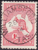
Earliest recorded date: 9-May-1899 · Latest recorded date: 7-Jan-1937
- Found in violet and blue 1909
Report an earlier or later use of the Type 1a datestamp here
Type 5
Earliest recorded date: 13-Apr-1937 · Latest recorded date: 9-Sep-1969
Report an earlier or later use of the Type 5 datestamp here
Type 5(s)
- Error creating thumbnail: File missing
Earliest recorded date: 18-Oct-1969 · Latest recorded date: 18-Jun-1976
Report an earlier or later use of the Type 5(s) datestamp here
| To the Index of Tasmanian Post Offices and Postal Markings
To the Tasmanian Datestamp Types main page |
Other Information[edit]
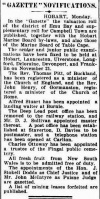
- 25-Oct-1898 - The Deep Lead Post Office has been removed to the railway station and Mr D J Sullivan appointed master thereat.
- 31-Oct-1915 - The post office was destroyed in a fire.
Links & References[edit]
| To the Index of Tasmanian Post Offices and Postal Markings
To the Tasmanian Datestamp Types main page |
Please contact GRD to report any errors and/or omissions or to provide better or 'missing' images, etc.


