Difference between revisions of "Chester"
From wiki new
| (One intermediate revision by one other user not shown) | |||
| Line 1: | Line 1: | ||
| − | |||
| − | |||
OPENED ''':''' 1st - June - 1910 | OPENED ''':''' 1st - June - 1910 | ||
Latest revision as of 04:20, 15 January 2017
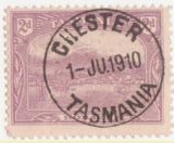
OPENED : 1st - June - 1910
CLOSED : 31st - May - 1914
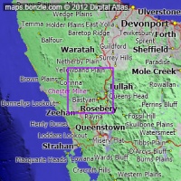
Chester was located approx 120 kms south West of Burnie.
Post offices close to Chester were:
- Rosebery approx. 10 kms
- Tullah approx. 20 kms
- Renison Bell approx. 22kms
click on above image or see Bonzle Maps for an enlargement
Datestamps[edit]
TYPE 2b
- Earliest recorded date: 1st - June - 1910 · Latest recorded date: 28th - November - 1913
- Only one known copy with date of opening.
- Rated : R in State period , RRRR in Commonwealth period.
Report an earlier or later use of the Type datestamp here
| To the Index of Tasmanian Post Offices and Postal Markings
To the Tasmanian Datestamp Types main page |
Other Information[edit]
Chester was a small township built around the Chester mine . The mine primarily extracted Gold , Iridium , Osmium and Tin.The Post Office was located in the main office building of the mine and Mr W T Buddon acted as postmaster. The town quickly declined in the Commonwealth period and there is very little recorded use of the cds in this period.
Links & References[edit]
| To the Index of Tasmanian Post Offices and Postal Markings
To the Tasmanian Datestamp Types main page |

