Difference between revisions of "Moltema"
From wiki new
(→Datestamps) |
m (1 revision) |
(No difference)
| |
Latest revision as of 14:28, 4 September 2013
Location:
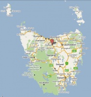
- situated 3km west of Elizabeth Town along Railton Road at 41° 27' 0" South, 146° 32' 0" East
see Google Map for an enlargement
Opened (as Whitefoord Hills): 1-Feb-1886 · Closed: 30-Jun-1971
- Renamed from Whitefoord Hills on 18-Sep-1915
Datestamps[edit]
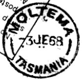
Type 2b
- Earliest recorded date: 5-Nov-1915 · Latest recorded date: 8-Apr-1969
- Found in blue 1918-20
Report an earlier or later use of the Type datestamp here
Type 6a
- Earliest recorded date: 7-May-1969 · Latest recorded date: 5-Sep-1969
- Rated RRR
Report an earlier or later use of the Type datestamp here
Type 6a(x)
- Earliest recorded date: 19-Dec-1969 · Latest recorded date: 1-Jul-1971
- Postcode deleted from Type 6a postmark
- Late date cancelled at Launceston PO
Report an earlier or later use of the Type datestamp here
| To the Index of Tasmanian Post Offices and Postal Markings
To the Tasmanian Datestamp Types main page |
Other Information[edit]
Links & References[edit]
| To the Index of Tasmanian Post Offices and Postal Markings
To the Tasmanian Datestamp Types main page |
Please contact the author of this page to report any errors and/or omissions or to provide better or 'missing' images, etc.

