Difference between revisions of "Adventure Bay"
| (3 intermediate revisions by 2 users not shown) | |||
| Line 17: | Line 17: | ||
| − | <gallery widths=200px heights=200px>file:Adventure Bay Map.gif</gallery> | + | <gallery widths=200px heights=200px>file:Ad.png |
| + | file:Adventure Bay Map.gif</gallery> | ||
''click on above image or see [https://maps.google.com.au/maps?q=Adventure+Bay,+Tasmania&hl=en&sll=-32.010396,135.119128&sspn=70.12224,141.855469&oq=adventure+bay&hnear=Adventure+Bay+Tasmania&t=m&z=12=A Google Maps ] for an enlargement'' | ''click on above image or see [https://maps.google.com.au/maps?q=Adventure+Bay,+Tasmania&hl=en&sll=-32.010396,135.119128&sspn=70.12224,141.855469&oq=adventure+bay&hnear=Adventure+Bay+Tasmania&t=m&z=12=A Google Maps ] for an enlargement'' | ||
== Numeral 2nd Allocation == | == Numeral 2nd Allocation == | ||
| + | |||
'''NUMERAL 319''' | '''NUMERAL 319''' | ||
| Line 40: | Line 42: | ||
| − | <gallery widths=200px heights=200px>File:</gallery> | + | <gallery widths=200px heights=200px>File:Adventure Bay.jpg</gallery> |
| Line 46: | Line 48: | ||
* Latest recorded date''':''' 10th - March - 1936 | * Latest recorded date''':''' 10th - March - 1936 | ||
| + | |||
| + | * Hardinge rated 6 (scarce +) but can be elusive to find a good strike | ||
| Line 110: | Line 114: | ||
{| style="color:brown; " cellpadding="5" cellspacing="0" border="1" | {| style="color:brown; " cellpadding="5" cellspacing="0" border="1" | ||
| − | | To the '''[[ | + | | To the '''[[Main Page]] (Index)''' |
| − | To the '''[[Tasmanian Datestamp Types]]''' | + | To the '''[[Tasmanian Datestamp Types]]''' page |
|} | |} | ||
| Line 122: | Line 126: | ||
== Links & References == | == Links & References == | ||
| − | |||
| − | |||
| − | |||
| − | |||
| − | |||
| − | |||
Latest revision as of 05:32, 15 February 2015
OPENED : 1st - December - 1890
CLOSED : 11th - April - 1974
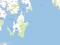
Adventure Bay was located on South Bruny Island and was 13 kms South East of Mills Reef - Alonnah
Post offices close to Adventure Bay were:
- Daniels Bay - Lunawanna 20 kms
- Barnes Bay 32 kms
- Error creating thumbnail: File missing
click on above image or see Google Maps for an enlargement
Numeral 2nd Allocation[edit]
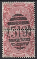
NUMERAL 319
- Allocated: 1st - December - 1890
- Rated: R
- Known used on pictorial
Datestamps[edit]
TYPE 1
- Error creating thumbnail: File missing
- Earliest recorded date: December - 1890
- Latest recorded date: 10th - March - 1936
- Hardinge rated 6 (scarce +) but can be elusive to find a good strike
Report an earlier or later use of the Type datestamp here
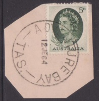
TYPE 4a
- Earliest recorded date: 13th - March - 1936
- Latest recorded date: 30th - January - 1959
Report an earlier or later use of the Type datestamp here
TYPE 4a(s)
- Earliest recorded date: 4th - April - 1959
- Latest recorded date: 16th - November - 1966
Report an earlier or later use of the Type datestamp here
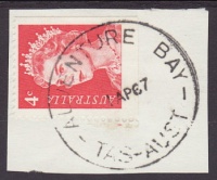
TYPE 5s(i)
- Earliest recorded date: 8th - December - 1966
- Latest recorded date: 26th - September - 1967
- Rated : RRR
Report an earlier or later use of the Type datestamp here
TYPE 5s(ii)
- Earliest recorded date: 2nd - December - 1967
- Latest recorded date: 11th - April - 1974
Report an earlier or later use of the Type datestamp here
| To the Main Page (Index)
To the Tasmanian Datestamp Types page |
Other Information[edit]
Adventure Bay was named by Captain Tobias Furneaux,after his ship the HMS Adventure anchored in the bay for 5 days after being separated from Captain James Cook (during his 2nd voyage)in March of 1773. Adventure Bay now operates as a Community Postal Agency.


