Difference between revisions of "Guildford Junction"
From wiki new
| (6 intermediate revisions by the same user not shown) | |||
| Line 6: | Line 6: | ||
| − | '''Location: ''' | + | '''Location: situated 44kms SW of [[Burnie]] at 41° 25' 0" South, 145° 42' 0" East ''' |
| − | * | + | * the closest post offices to Guildford Junction during it's period of operation were at [[Waratah]] and [[Parrawe]] |
* | * | ||
| + | <gallery widths=200px heights=200px>file:guildford junction location map small.jpg</gallery> | ||
| − | + | ''see [https://www.google.com.au/maps/place/Guildford+Junction/@-41.2611002,145.5761085,11z/data=!4m2!3m1!1s0xaa7b08ef5728b9d7:0x60ac2e3fc9c0454b Google Maps] for an enlargement | |
| − | |||
| − | |||
| − | |||
| − | ''see [] for an enlargement | ||
| Line 65: | Line 62: | ||
* examples of this postmark are rated '''RR''' | * examples of this postmark are rated '''RR''' | ||
| + | |||
| + | * this datestamp with all but the letters ''''RD'''' excised was used as Cut Down Relief cds (x) at [[Calder Upper]] · ERD: 20-OCT-1969 · LRD: 10-NOV-1969 | ||
[http://tps.org.au/bb/viewtopic.php?f=5&t=639 ''Report an earlier or later use of the Type datestamp here''] | [http://tps.org.au/bb/viewtopic.php?f=5&t=639 ''Report an earlier or later use of the Type datestamp here''] | ||
| Line 81: | Line 80: | ||
== Links & References == | == Links & References == | ||
| + | |||
| + | * a photo of the Guildford Junction school may be viewed via this link [http://catalogue.statelibrary.tas.gov.au/item/?id=AB713-1-2942] | ||
Latest revision as of 03:44, 20 May 2014
OPENED: 1-AUG-1900 · CLOSED: 30-JUN-1969
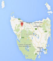
Location: situated 44kms SW of Burnie at 41° 25' 0" South, 145° 42' 0" East
- the closest post offices to Guildford Junction during it's period of operation were at Waratah and Parrawe
see Google Maps for an enlargement
Barred Numeral Postmark[edit]
Second Allocation
- barred numeral '390' was allocated to this office
- examples are rated RRRRR and have not been reported on other than the Pictorial issues
Datestamps[edit]
Type 1
- Earliest recorded date: 11-AUG-1900 · Latest recorded date: 17-MAR-1938
- examples of this postmark with 1900-1912 dates are rated 'S' by Hardinge
- examples struck in blue ink from the 1908-1909 period have been reported
Report an earlier or later use of the Type datestamp here
Type 5
- Earliest recorded date: 24-MAR-1938 · Latest recorded date: 28-JUL-1966
Report an earlier or later use of the Type datestamp here
Type 5(s)
- Earliest recorded date: 1-SEP-1966 · Latest recorded date: 5-MAY-1969
- examples of this postmark are rated RR
- this datestamp with all but the letters 'RD' excised was used as Cut Down Relief cds (x) at Calder Upper · ERD: 20-OCT-1969 · LRD: 10-NOV-1969
Report an earlier or later use of the Type datestamp here
| To the Index of Tasmanian Post Offices and Postal Markings
To the Tasmanian Datestamp Types main page |
Other Information[edit]
Links & References[edit]
- a photo of the Guildford Junction school may be viewed via this link [1]
| To the Index of Tasmanian Post Offices and Postal Markings
To the Tasmanian Datestamp Types main page |
Please contact the author of this listing [2] to report any errors and/or omissions or to provide better or 'missing' images, etc.

