Difference between revisions of "Rosevale"
| Line 20: | Line 20: | ||
| − | <gallery widths=200px heights=200px>file: | + | <gallery widths=200px heights=200px>file:Ros.png</gallery> |
Latest revision as of 06:55, 18 July 2014
__this page is currently being prepared by __
OPENED: 18th - March - 1874
CLOSED: 22nd - December - 1911
REOPENED: 2nd - January - 1913
CLOSED: 19th - June - 1968
Location: 41° 25' 0" South, 146° 56' 0" East
- situated approx. 35km WNW of Launceston
- the closest post offices to Rosevale were at Black Sugar Loaf (Birralee), Selbourne and Westwood
- Error creating thumbnail: File missing
see Google Map for an enlargement
Barred Numeral Postmark[edit]
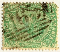
Second Allocation
Allocated BN163
Rated:
Datestamps[edit]
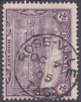
Town name hyphenated 'Rose-Vale' for reasons unknown
- Earliest recorded date: 25th - March - 1896
- Latest recorded date: 4th - December - 1911
- Rated: RR
- Earliest recorded date: 16th - March - 1913
- Latest recorded date: 10th - September - 1921
- Rated: RRRR
Report an earlier or later use of the Type 1a datestamp here
- Earliest recorded date: 5th - September - 1923
- Latest recorded date: 16th - October - 1950
- Rated: RR
Report an earlier or later use of the Type datestamp here
- Earliest recorded date: 19th - October - 1950
- Latest recorded date: 19th - June - 1968
- Rated: R
Report an earlier or later use of the Type datestamp here
| To the Index of Tasmanian Post Offices and Postal Markings
To the Tasmanian Datestamp Types main page |
Other Information[edit]
Links & References[edit]
| To the Index of Tasmanian Post Offices and Postal Markings
To the Tasmanian Datestamp Types main page |
Please contact the author of this page to report any errors and/or omissions or to provide better or 'missing' images, etc.


