Difference between revisions of "Pyengana West"
From wiki new
m (1 revision) |
|
(No difference)
| |
Latest revision as of 14:28, 4 September 2013
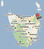
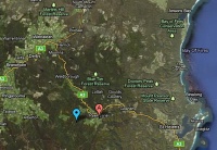
Location: 41° 18' 0" South, 147° 56' 0" East
- situated approximately 5kms WSW of Pyengana
Click on the RH map for an enlargement - the blue marker indicates the approximate location
- Opened: 07-OCT-1925 · Closed: 12-OCT-1943 (Telephone Office only)
Datestamp[edit]
- Earliest recorded date: 31-JUN-1931 · Latest recorded date: 31-MAY-1942
- Rated RRRRR
Very few complete copies known (T.O only) but mail was cancelled at the office as postal articles are known
Report an earlier or later date date here
| To the Index of Tasmanian Post Offices and Postal Markings
To the Tasmanian Datestamp Types main page |
Other Information[edit]
- 1. report of extension of phone line from Pyengana in The Mercury, Wednesday 05-AUG-1925
- 2. report of bushfire nearly destroying the office in The Examiner, Wednesday 15-FEB-1939
Links & References[edit]
| To the Index of Tasmanian Post Offices and Postal Markings
To the Tasmanian Datestamp Types main page |
Please contact the author of this page to report any errors and/or omissions or to provide better or 'missing' images, etc.
