Difference between revisions of "Andover"
From wiki new
m (1 revision) |
|||
| Line 15: | Line 15: | ||
* Re-named Andover: '''01-SEP-1893''' · Closed: '''28-DEC-1966''' | * Re-named Andover: '''01-SEP-1893''' · Closed: '''28-DEC-1966''' | ||
| − | |||
| Line 71: | Line 70: | ||
* Earliest recorded date: '''19-MAR-1960''' · Latest recorded date: '''02-NOV-1966''' | * Earliest recorded date: '''19-MAR-1960''' · Latest recorded date: '''02-NOV-1966''' | ||
| + | {| style="color:brown; " cellpadding="5" cellspacing="0" border="1" | ||
| + | | To the '''[[Main Page]] (Index)''' | ||
| + | To the '''[[Tasmanian Datestamp Types]]''' page | ||
| + | |} | ||
== Other Information == | == Other Information == | ||
| Line 82: | Line 85: | ||
== Links & References == | == Links & References == | ||
| − | |||
| − | |||
| − | |||
| − | |||
| − | |||
| − | |||
Revision as of 22:42, 4 June 2014
___this page is currently being prepared by R.E.___
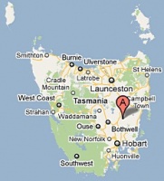
Location: 42° 20' 0" South, 147° 27' 0" East
- formerly known as Eastern Marshes Siding, re-named Andover from 01-SEP-1893
- see also Eastern Marshes
see Google Map for an enlargement
- Re-named Andover: 01-SEP-1893 · Closed: 28-DEC-1966
Barred Numeral Postmark
Second Allocation
- allocated BN 283
- Rated RR
This Second Allocation barred numeral postmark can be found cancelling Pictorial issues
Datestamps
An altered datestamp with circle stops
- Earliest recorded date: 19-JAN-1896 · Latest recorded date: 07-AUG-1937
- Eastern Marshes Siding datestamp used until 23-SEP-1893
Very worn towards the end of use
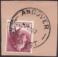
- Earliest recorded date: 17-NOV-1937 · Latest recorded date: 28-DEC-1959
- Datestamp was manufactured during September 1937
- Recorded with an inverted dateline during the 1950-52 period (see example above)
Seen in greyish ink during 1956
Original Type 5 datestamp fitted with a dateline comprised of small characters
- Earliest recorded date: 19-MAR-1960 · Latest recorded date: 02-NOV-1966
| To the Main Page (Index)
To the Tasmanian Datestamp Types page |
Other Information


