Difference between revisions of "Ramsgate"
From wiki new
| Line 19: | Line 19: | ||
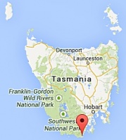
<gallery widths=200px heights=200px>file:ramsgate location map small.jpg</gallery> | <gallery widths=200px heights=200px>file:ramsgate location map small.jpg</gallery> | ||
| − | ''see [ Google Map] for an enlargement'' | + | ''see [https://www.google.com.au/maps/place/Cockle+Creek+Rd/@-43.5810913,146.8897929,15z/data=!4m2!3m1!1s0xaa6c0e9e00c28065:0x5fdf6db3819e95de Google Map] for an enlargement - note that Ramsgate was near where the road crosses Cockle Creek.'' |
Revision as of 00:50, 18 May 2014
OPENED: 1-JUL-1895 · CLOSED: 1-NOV-1922
Location:
- opened as Recherche Bay 11-MAY-1857 · renamed Ramsgate from 1-JUL-1895
- a Recherche Bay datestamp should exist but is yet to be verified
- facilities were transferred to Catamaran on 1-NOV-1922 however the datestamp remained is use for a few days after that
see Google Map for an enlargement - note that Ramsgate was near where the road crosses Cockle Creek.
Barred Numeral Postmark
Second Allocation
- BN75 originally allocated to Recherche Bay was used at Ramsgate although it's application to the mail may have been abandoned much earlier than usual for this postmark type
- manuscript '75' cancels have been reported
Datestamps
Type 1 (Circle Stops)
- Earliest recorded date: 9-AUG-1899 · Latest recorded date: 6-NOV-1922
Report an earlier or later use of the Type datestamp here
| To the Index of Tasmanian Post Offices and Postal Markings
To the Tasmanian Datestamp Types main page |
Other Information
Links & References
| To the Index of Tasmanian Post Offices and Postal Markings
To the Tasmanian Datestamp Types main page |
Please contact Ross Ewington [1] to report any errors and/or omissions or to provide better or 'missing' images, etc.


