Difference between revisions of "Grassy"
m (1 revision) |
|||
| Line 9: | Line 9: | ||
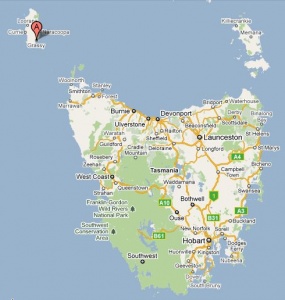
| − | <gallery widths= | + | <gallery widths=300px heights=300px>file: grassy map.jpg </gallery> |
''see [http://maps.google.com.au/maps?rlz=1T4ACAW_en___AU330&q=grassy+king+island+tasmania&um=1&ie=UTF-8&hq=&hnear=0xaa80c6209fc0c3ed:0x403c94dd0ddf9c0,Grassy+TAS&gl=au&ei=poL1TfroDJG6ugPT9rHRBg&sa=X&oi=geocode_result&ct=title&resnum=1&ved=0CB0Q8gEwAA Google Map] for an enlargement'' | ''see [http://maps.google.com.au/maps?rlz=1T4ACAW_en___AU330&q=grassy+king+island+tasmania&um=1&ie=UTF-8&hq=&hnear=0xaa80c6209fc0c3ed:0x403c94dd0ddf9c0,Grassy+TAS&gl=au&ei=poL1TfroDJG6ugPT9rHRBg&sa=X&oi=geocode_result&ct=title&resnum=1&ved=0CB0Q8gEwAA Google Map] for an enlargement'' | ||
Latest revision as of 23:09, 23 April 2014
Location: 40° 3' 0" South, 144° 3' 0" East
- situated on the south east coast of King Island in Bass Strait approx. 22kms SE of Currie
- other offices to have operated in a fairly close proximity to Grassy were at Moorden (TO only) and Lymwood
see Google Map for an enlargement
Opened (the first time): 11-Mar-1918 · Closed (for the third and final time): 27-Feb-1991
- The post office closed briefly in 1920 (12-Sep to 13-Oct) and then from 18-May-1935 until 3-Sep-1943
Datestamps[edit]
Type 4
- Earliest recorded date: 1919 · Latest recorded date: 18-May-1935
- Rated RRRRR in both the first opening period 11-Mar-1918 to 11-Sep-1920 and the second opening period 14-Oct1920 until 17-May 1935
Report an earlier or later use of the Type datestamp here
Type 5(i)
- Earliest recorded date: 4-Sep-1943 · Latest recorded date: 19-Jan-1955
- CDS destroyed in fire 19-Mar-1955
Report an earlier or later use of the Type datestamp here
Type 5(ii)
- Earliest recorded date: 16-Jun-1955 · Latest recorded date: 24-Sep-1969
- Smaller circle and longer right arc than 5(i)
Report an earlier or later use of the Type datestamp here
Type 5(ii)(s)
- Earliest recorded date: 9-Oct-1969 · Latest recorded date: 16-Feb-1988
Report an earlier or later use of the Type datestamp here
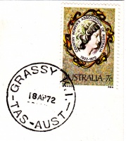
Type 6a
- Earliest recorded date: 24-Jul-1973 · Latest recorded date: 27-Feb-1988
Report an earlier or later use of the Type datestamp here
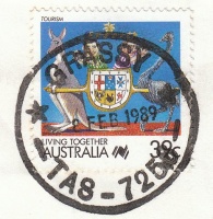
Type R7(i)
- Earliest recorded date: 19-Oct-1988 · Latest recorded date: 22-Nov-1989
- Found in violet and black ink
Report an earlier or later use of the Type datestamp here
Type R7(ii)
- Earliest recorded date: 13-Dec-1989 · Latest recorded date: 17-Nov-1990
- Almost identical to R7(i) but with shorter, thinner arcs
Report an earlier or later use of the Type datestamp here
| To the Index of Tasmanian Post Offices and Postal Markings
To the Tasmanian Datestamp Types main page |
Other Information[edit]
Links & References[edit]
| To the Index of Tasmanian Post Offices and Postal Markings
To the Tasmanian Datestamp Types main page |
Please contact GRD of this page to report any errors and/or omissions or to provide better or 'missing' images, etc.
