Difference between revisions of "Temma"
From wiki new
| Line 17: | Line 17: | ||
file: temma map 2.jpg </gallery> | file: temma map 2.jpg </gallery> | ||
| − | ''see [ | + | ''see [https://maps.google.com.au/maps?q=Temma,+Tasmania&hl=en&ll=-41.153842,145.033264&spn=1.557237,3.56781&sll=-25.335448,135.745076&sspn=57.774,114.169922&z=9 Google Map] for an enlargement'' |
Revision as of 20:56, 22 September 2013
OPENED: 24-MAY-1910 · CLOSED: 31-JUL-1960
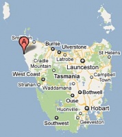
Location: 41° 14' 0" South, 144° 42' 0" East
- situated 34.5km South of Marrawah
- the closest post office to Temma was at Balfour
- little business was conducted at the post office during the last 10 years or so of operation
see Google Map for an enlargement
Datestamps
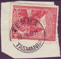
- Earliest recorded date: 22-JUN-1910 · Latest recorded date: 02-JAN-1959
- Rated RR throughout it's long period of use
- Datestamp was ordered on 20-MAY-1910
- Complete strikes can be elusive
- Reported in violet ink with 1950 dates
Report an earlier or later use of the Type 2a datestamp here
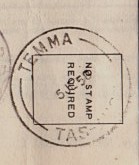
- Earliest recorded date: 01-MAY-1959 · Latest recorded date: 09-JUN-1960
- Rated RRRRR
- Only 4 or 5 examples have been found
Report an earlier or later use of the Type 5s datestamp here
| To the Index of Tasmanian Post Offices and Postal Markings
To the Tasmanian Datestamp Types main page |
Other Information
Links & References
| To the Index of Tasmanian Post Offices and Postal Markings
To the Tasmanian Datestamp Types main page |
Please contact [mailto: the author] of this page to report any errors and/or omissions or to provide better or 'missing' images, etc.


