Difference between revisions of "Wynyard"
m (1 revision) |
|
(No difference)
| |
Latest revision as of 14:28, 4 September 2013
__this page is currently being prepared by R.E.__
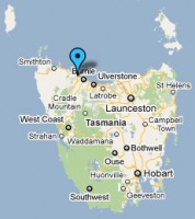
Location: 41° 0' 0" South, 145° 43' 0" East
- situated approx. 15km NW of Burnie
- the closest post office to Wynyard was at Flowerdale
see Google Map for an enlargement
Opened: · Open
Contents
Barred Numeral Postmark[edit]
First Allocation
Allocated BN
Rated:
Second Allocation
Allocated BN
Rated:
Datestamps[edit]
- Earliest recorded date: · Latest recorded date:
- Rated
Report an earlier or later use of the Type datestamp here
- Earliest recorded date: · Latest recorded date:
- Rated
Report an earlier or later use of the Type datestamp here
| To the Index of Tasmanian Post Offices and Postal Markings
To the Tasmanian Datestamp Types main page |
Other Datestamps[edit]
Machine Cancellations[edit]
First Type
Earliest Recorded Use: · Latest Recorded Use:
Second Type
Earliest Recorded Use: · Latest Recorded Use:
Second Type - PAID
Earliest Recorded Use: · Latest Recorded Use:
Other Postal Markings and Items[edit]
Other Information[edit]
Links & References[edit]
| To the Index of Tasmanian Post Offices and Postal Markings
To the Tasmanian Datestamp Types main page |
Please contact [mailto: the author] of this page to report any errors and/or omissions or to provide better or 'missing' images, etc.

