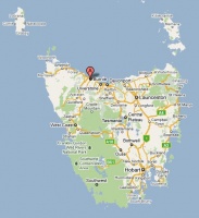
Mooreville Road
From wiki new
OPENED: 1-JUL-1906 · CLOSED: 29-AUG-1975
Location:
- situated 6km south of Burnie somewhere near 41° 7' 0" South, 145° 52' 0" East
- nearby post offices have included Mooreville Road West, Burnie Upper and Ridgley
see Google Map for an enlargement
Datestamps
- Earliest recorded date: 10-JUL-1906 · Latest recorded date: 25-AUG-1937
- Rated RR in both the State and Commonwealth periods
Report an earlier or later use of the Type datestamp here
- Earliest recorded date: 30-Jun-1938 · Latest recorded date: 14-FEB-1958
- Rated R
- CDS manufactured SEP-1937
Report an earlier or later use of the Type datestamp here
- Earliest recorded date: 12-APR-1959 · Latest recorded date: 29-AUG-1975
Report an earlier or later use of the Type datestamp here
| To the Index of Tasmanian Post Offices and Postal Markings
To the Tasmanian Datestamp Types main page |
Other Information
Links & References
| To the Index of Tasmanian Post Offices and Postal Markings
To the Tasmanian Datestamp Types main page |
Please contact the author of this page to report any errors and/or omissions or to provide better or 'missing' images, etc.

