Liena
Location:
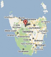
- Liena is located on the upper reaches of the Mersey River and is the most western of a string of communities and localities lying below the Western Tiers.
- Nearby localities with post offices included Mole Creek, Claude Road, Gowrie Park and Cethana.
see Google Map for an enlargement
Opened: 1-Oct-1900· Closed: 30-June-1971
Contents
[hide]Manuscript markings[edit]
Manuscript cancellations of LIENA were applied at either Liena or Mole Creek in 1911 when the original Type 1 cds was being altered to show the correct spelling of the community.
Barred Numeral Postmark[edit]
BN392 (probably the last number allocated) was allocated to Liena from 1-OCT-1900 and was only used for a brief period.
- Rated RRRR
Datestamps[edit]
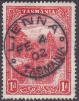
Type 1 (original)
- The datestamp was delivered with Liena misspelt LIENNA and was eventually sent for correction in Februrary 1911.
- Earliest recorded date: 18-Dec-1900· Latest recorded date: 3-Feb-1911
- Rated RR
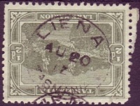
Type 1 (altered)
- The altered datestamp has a lopsided appearance due the the removal of the second N.
- Earliest recorded date: 10-May-1911· Latest recorded date: 10-Jan-1938
- Rated RR on State issues and R on Commonwealth issues
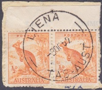
Earliest recorded date: 2-Jul-1938· Latest recorded date: 12-Feb-1970
This version has a small first number on the year.
Earliest recorded date: 28-Jan-1971· Latest recorded date: 30-Jun-1971
Rated RRRRR
Report an earlier or later use of the Type datestamp here
| To the Index of Tasmanian Post Offices and Postal Markings
To the Tasmanian Datestamp Types main page |
Other Information[edit]
Links & References[edit]
| To the Index of Tasmanian Post Offices and Postal Markings
To the Tasmanian Datestamp Types main page |
Please contact GRD of this page to report any errors and/or omissions or to provide better or 'missing' images, etc.
