Orrville
From wiki new
Opened: 25-MAR-1898 · Closed: 21-MAR-1900
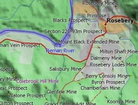
Location: 41°47'51" South 145°29'43" East
- mining township associated with the Colebrook Hill Mine approx. 4 km SW of Rosebery
Click on the map for an enlarged view of the locality
Barred Numeral Postmarks[edit]
- It is possible that BN353 was allocated to Orrville after Teepookana closed temporarily in 1896 but this has not been confirmed by a "tie" or any documentary evidence
Datestamps[edit]
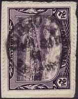
- Earliest Date: 13-JUL-1898 · Latest Date: 28-JAN-1900
- Rated RRRR
Examples on Pictorials
| To the Index of Tasmanian Post Offices and Postal Markings
To the Tasmanian Datestamp Types main page |
Other Information[edit]
- opening of the post office reported in The Examiner on Thursday,April 14th 1898
- closure of the office reported in The Mercury on Tuesday, April 3rd 1900
Links & References[edit]
| To the Index of Tasmanian Post Offices and Postal Markings
To the Tasmanian Datestamp Types main page |
Please contact the author of this page to report any errors and/or omissions or to provide better or 'missing' images, etc.
